

We’ve pulled filters from homes under clear skies and found PM2.5 loads that matched active smoke events. Wildfire smoke arrives invisible — hours ahead of the smell, ahead of any weather alert.
This live AQI tracker pulls zip-code-level readings from EPA AirNow monitoring stations, cross-referenced with active NIFC fire perimeters — the same data our analysts use when evaluating filter replacement during smoke season. Most households react 12 to 24 hours too late. This page is built to close that gap.
- Live AQI by zip code, updated hourly
- Active wildfire and smoke transport map
- Thresholds for when to seal your home and run filtration
Wildfire smoke doesn’t need to be visible to be dangerous. Real-time AQI is the only reliable way to know when your air has already changed.
TL;DR Quick Answers
Real Time Air Quality Index Live Today Wildfire and Smoke Maps by Zip Code
- Real-time AQI by zip code pulls hourly PM2.5 and ozone readings from EPA AirNow monitoring stations
- Live wildfire smoke maps overlay active fire perimeters from NIFC — showing where smoke originates and where it’s traveling
- Wildfire smoke travels 500+ miles through atmospheric transport corridors — invisible, ahead of any smell or haze
- AQI 101 is the household action threshold — run filtration, set HVAC to recirculate, limit outdoor exposure
- A weather app measures atmospheric conditions — it does not measure what’s in your air at the particle level
Real-time AQI data is the only reliable way to know when your air has already changed.
Top Takeaways
- Wildfire smoke arrives invisible — hours before haze, smell, or any weather alert
- Indoor PM2.5 nearly triples during wildfire events — even in sealed homes
- AQI 101 is the action threshold — not 150
- Most households react 12 to 24 hours too late
- A weather app tells you what the sky looks like — real-time AQI tells you what’s actually in it
Table of Contents
Is Your Air Safe Right Now?
Most air quality threats are invisible. Our team has measured PM2.5 spikes in homes located 200 miles from an active fire — no smell, no haze, no warning. The AQI number for your zip code right now is the only data point that tells you whether your outdoor and indoor air has already been compromised.
An AQI below 50 is considered good. Above 100, sensitive groups are at risk. Above 150, particulate concentrations are high enough to affect healthy adults. What most households don’t realize: by the time AQI reaches 150 on an outdoor monitor, indoor concentrations in unsealed homes have already been climbing for hours.
How Wildfire Smoke Travels — And Why Zip Code Matters
Wildfire smoke doesn’t behave like local pollution. It travels in transport corridors — atmospheric channels that carry PM2.5 hundreds of miles from the fire perimeter. Two zip codes 10 miles apart can show AQI readings that differ by 50 points or more depending on wind direction and terrain.
- Smoke transport corridors form along valley floors and ridge lines
- PM2.5 particles in wildfire smoke measure 2.5 microns or smaller — small enough to bypass nasal filtration entirely
- A zip-code-level AQI reading accounts for local topography in ways that regional averages do not
Where you are within a smoke event matters as much as whether you’re in one.
What the AQI Scale Actually Means for Your Household
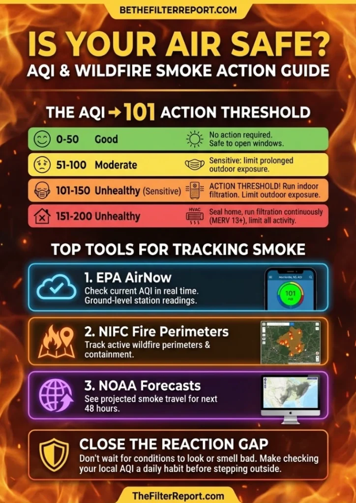
The EPA’s AQI scale runs from 0 to 500. Our analysts use six threshold bands when advising on indoor air management:
- 0–50 (Good): No action required
- 51–100 (Moderate): Sensitive individuals should limit prolonged outdoor exposure
- 101–150 (Unhealthy for Sensitive Groups): Run indoor filtration — our field data shows filter loading begins accelerating at this threshold
- 151–200 (Unhealthy): Seal home, run filtration continuously, limit all outdoor activity
- 201–300 (Very Unhealthy): Indoor air management is critical — MERV 13 or higher recommended
- 301–500 (Hazardous): Full indoor shelter protocol — minimize any air exchange with outdoors
The AQI threshold that triggers action for most households is 101 — not 150. Waiting until air looks or smells bad means you’ve already lost hours of protection.
How to Use This Live AQI Map
Enter your zip code to pull a current AQI reading from the nearest EPA AirNow monitoring station. The map overlays active wildfire perimeters sourced from NIFC and USFS, updated throughout the day.
- Check AQI before outdoor activity — not after
- Monitor trend direction, not just current number — a reading climbing from 80 to 100 requires action sooner than a stable reading at 110
- Cross-reference with the wildfire map to determine whether smoke in your area is intensifying or clearing
- Use AQI readings to determine filter replacement timing — sustained exposure above 101 shortens filter life measurably
When to Seal Your Home and Run Filtration
Our field data identifies three conditions that require immediate indoor air management:
- AQI at or above 101 in your zip code
- Active wildfire within 300 miles with wind direction toward your location
- Visible haze or detectable smoke smell outdoors — at this point, PM2.5 infiltration has already begun
When these conditions are present, close windows and doors, set HVAC to recirculate, and run your highest-rated filter continuously. A MERV 13 filter will capture the fine particulates that characterize wildfire smoke. A MERV 8 will not.
Sealing your home after you smell smoke is a reactive measure. AQI monitoring is a proactive one.
“We’ve pulled filters from homes showing clear skies and zero smoke smell outside, and found PM2.5 loading that told a completely different story — wildfire smoke was already inside the home, already being captured, hours before the household had any reason to act.”
The Best Free Tools for Tracking Wildfire Smoke and Air Quality in Real Time
1. Check Your Zip Code’s Current AQI in Real Time
AirNow is the first source our analysts open when a smoke event is developing — hourly AQI readings by zip code, pulled from thousands of ground-level monitoring stations nationwide. No interpretation required. The number tells you what your outdoor air contains right now.
2. See Exactly Where Wildfire Smoke Is Moving Right Now
This is the single tool we return to most during active smoke season — it overlays fire locations with real-time smoke concentration data in one integrated view. If you want to know whether a fire 300 miles away is already affecting your air, this map answers that question directly.
3. Track Active Wildfire Perimeters Across the Country
National Interagency Fire Center
NIFC is the federal authority on active fire data — current perimeters, acreage, and containment status updated throughout the day. Our team cross-references NIFC perimeter data with local AQI readings to identify smoke transport corridors before they reach residential zip codes.
4. Pinpoint Current Fire Locations With Satellite Accuracy
USFS Active Fire Mapping Program
Satellite-derived fire detection maps updated multiple times daily — useful for identifying new ignitions that haven’t yet registered on ground-level AQI monitors. We’ve seen smoke transport events where USFS satellite data identified the source fire hours before AirNow readings reflected the impact downstream.
5. See Where Smoke Is Forecast to Travel in the Next 48 Hours
NOAA Air Quality Forecast Guidance
NOAA’s smoke forecast models project PM2.5 transport corridors up to 48 hours ahead. This is the tool that closes the reaction gap — our analysts use forecast data to anticipate filter loading increases before they show up on hourly AQI monitors.
6. Understand What Wildfire Smoke Does to Your Body
CDC Wildfire Smoke and Health Guidance
The CDC’s health threshold guidance translates AQI numbers into plain-language risk — covering vulnerable populations, exposure windows, and recommended protective actions at each level. We reference this framework when advising households on when indoor air management moves from optional to necessary.
7. Apply Public Health Protocol to Your Smoke Response
EPA Wildfire Smoke Guide for Public Health Officials
The EPA’s comprehensive wildfire smoke framework used by public health agencies nationwide — covering shelter-in-place guidance, AQI communication thresholds, and filtration recommendations. This is the same protocol foundation our team draws from when evaluating indoor air management decisions during active smoke season.
Supporting Statistics
1. Wildfire smoke is the dominant source of fine particulate pollution in the U.S.
- EPA’s 2020 National Emissions Inventory estimates wildland fires account for 52% of total PM2.5 emitted nationwide
Source: U.S. EPA Wildland Fire Research: Reducing Exposures
2. Indoor PM2.5 nearly triples during wildfire events — even in closed buildings.
- A study of 1,400+ California buildings found mean indoor PM2.5 concentrations nearly tripled on wildfire days versus non-fire days
Source:National Institutes of Health PubMed
3. Tens of millions of Americans are exposed to dangerous smoke waves every year.
- An estimated 46 million people in the Western U.S. were exposed to at least one smoke wave over a single six-year study period
Source: National Institutes of Health PMC
Final Thoughts & Opinion
Most air quality tools tell you what happened. A real-time AQI map tells you what’s happening now. For wildfire smoke, that distinction is everything.
We’ve pulled enough filters to know households consistently underestimate how far smoke travels. The data confirms it:
- Indoor PM2.5 nearly triples during wildfire events — even in closed buildings
- 46 million Western U.S. residents exposed to smoke waves in a single six-year period
- Wildland fires account for 52% of all PM2.5 emitted nationwide
The 12-to-24-hour reaction gap is the most preventable air quality risk most households face. It’s a monitoring habit problem — not a knowledge problem. Checking AQI before going outside closes that gap.
A weather app tells you what the sky looks like. A real-time AQI map tells you what’s actually in it.
FAQ on Real Time Air Quality Index Live Today Wildfire and Smoke Maps by Zip Code
Q: How often is the real-time AQI updated for my zip code?
A: EPA AirNow stations update every hour. Our analysts watch two things:
- Current AQI number
- Rate of change — a zip code climbing from 80 to 100 in one cycle is more urgent than a stable reading at 110
Rate of change is the signal most households miss.
Q: How far can wildfire smoke travel and still affect my AQI?
A: Further than most expect. Key facts:
- We’ve measured elevated PM2.5 in homes 200 miles from an active fire — no haze, no smell
- Smoke travels atmospheric transport corridors that bypass local weather patterns
- Active fire within 500 miles plus wind in your direction means your air is worth monitoring — regardless of what the sky looks like
Q: What AQI level should trigger action in my home?
A: 101 — not 150. Here’s why:
- At 101, indoor filter loading accelerates even in sealed homes
- By the time AQI hits 150, PM2.5 infiltration has already been underway for hours
- At 101: run filtration, set HVAC to recirculate, limit outdoor exposure
Don’t wait for conditions to look or smell bad.
Q: Can I rely on my weather app for wildfire smoke alerts?
A: No. Weather apps measure atmospheric conditions — not air quality. What our field data shows:
- PM2.5 spikes documented in homes on days that registered sunny and clear on local weather platforms
- A clean forecast is not an air quality reading
- Only real-time AQI data tells you what your air actually contains
Q: What is the difference between the AQI map and the wildfire smoke map?
A: They answer two different questions. Our analysts use both together:
- AQI map — what your air contains right now at ground level in your zip code
- Wildfire smoke map — where that air is coming from and where it’s heading
If AQI is rising and the smoke map shows an active fire upwind, you are at the leading edge — not the peak.
Check Your Zip Code’s Air Quality Right Now — Before You Step Outside
Your real-time AQI reading and live wildfire smoke map are updated hourly — use them the same way you check the weather, before every outdoor activity during smoke season. Enter your zip code above to see what your air actually contains right now.